
Birmingham Set For Storm Freya Battering
3 March 2019, 08:24 | Updated: 3 March 2019, 08:26
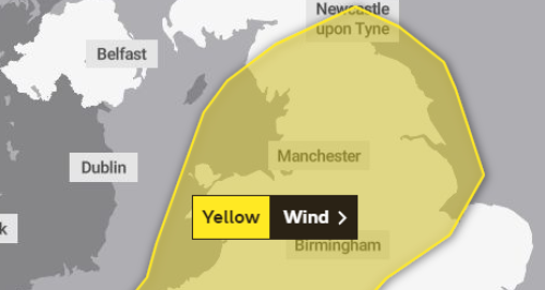

Storm Freya is set to bring strong winds to Birmingham and the Black Country on Sunday and into Monday, with a yellow weather warning having been issued by the Met Office.
Parts of the UK could see up to 80mph winds, dangerous conditions and travel disruption to England and Wales on Sunday.
Forecasters predict the storm will hit on Sunday afternoon and be severe enough to risk injuries and danger to life from flying debris and large waves.
There could also be damage to buildings and trees, with road hazards and power cuts possible.
The Met Office has issued a severe weather warning, which runs from 3pm on Sunday to 6am on Monday.
It is warning people to be aware of possible hazards including tiles being blown from roofs, fallen branches, and beach material being thrown on to sea fronts and coastal roads.
Strong winds were seen across Scotland on Saturday night as a separate weather system moved over.
A gust of around 70mph was recorded at South Uist, while winds of 45 to 50mph blew through Glasgow and Edinburgh.
Freya will have moved into the North Sea by rush hour on Monday morning, although there will likely be some residual impacts in its wake.
Met Office forecaster Craig Snell said "We can expect some branches and a few trees being blown down and there's also scope for some tiles being blown from roofs and also some power cuts as well," Mr Snell said.
It will still be quite breezy along the North Sea coast of England, but the winds will have died down significantly.
Temperatures are expected to reach between 8C (46F) and 12C (54F) in England and Wales on Sunday, while they will remain below 10C (50F) in Scotland.